The City of Oxnard is committed to prioritizing transportation safety and decreasing the number of traffic related deaths and serious injuries on City streets.
This Local Road Safety Plan (LRSP) builds on existing and ongoing City safety efforts by proactively identifying and evaluating hot spots and systemic risk factors throughout the City. The LRSP identifies proven countermeasures that can be implemented through roadway design changes, as well as key partnerships with safety stakeholders.
This plan applies the Safe System Approach, an international best practice framework, as the foundation for this LRSP.
The Local Road Safety Plan was adopted by the City Council on January 17, 2003. Key highlights are shared below, and the full report can be viewed and downloaded here:
More Information
Oxnard will have an equitable, sustainable, and multimodal transportation system where people of all ages, abilities, and backgrounds can travel safely throughout the city.
- Prioritize traffic safety programs and infrastructure investments for locations with high collision rates or severity.
- Foster a citywide culture of safety where all road users have shared responsibility and a feeling of belonging on streets and sidewalks.
- Ensure equitable access to safety education and resources by removing barriers, such as language or technology.
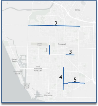
Through the LRSP process, 15 Emphasis Area were selected for project development. The 15 Emphasis Areas are a combination of 5 hot spot corridors and 10 collision profiles.
Hot Spot Corridors
Hot spot corridors are locations in Oxnard with a relatively high number of collisions and are well-suited for grant applications. These corridors reflect a variety of land use contexts and crash types in Oxnard.
- Ventura Road from 5th Street to Wooley Road*
- Gonzales Road from Victoria Avenue to Rose Avenue
- Wooley Road from Factory Lane to Pacific Avenue
- Saviers Road from Laurel Street to Pleasant Valley Road
- Bard Road from Saviers Road to Pleasant ValleyRoad*
*The City submitted grant applications through the Highway Safety Improvement Program for the Ventura Road and Bard Road corridors in September 2022.

Note: each corridor’s number does not indicate a rank but is used for identification purposes.
Collision Profiles
The collision profiles pair a type of collision with a type of location. The profiles were developed by analyzing Oxnard collision data with a focus on all injury collisions, collisions involving a fatality or severe injury, bicycle-involved collisions, and pedestrian-involved collisions.
- Unsafe Speed Collisions Along Roadways with 4 – 5 Lanes
- Broadside Collisions at Signals without Fully Protected Left Turns
- Driving Under the Influence of Drugs or Alcohol at Primary Roadway Intersections
- Nighttime Collisions on 4 – 5 Lane Roadways
- Hit Object Collisions at Major Intersections
- Pedestrian or Bicycle-Involved Collisions on Roadways with 2 – 3 Lanes and ≤ 25 mph Posted Speed Limit
- Pedestrian or Bicycle-Involved Collisions at Major Unsignalized Intersections
- Bicycle-Involved Collisions with Vehicles Proceeding Straight at Signals
- Pedestrian-Involved Collisions on Roadways with 4 – 5 Lanes and 30 – 45 mph Speed Limit
- Pedestrian-Involved Collisions Midblock Along Primary Roadways
Collision Profile Maps
2.82 MB PDF | Updated 04/09/24